Pennsylvania Above Ground Survey (PAGS)
The Pennsylvania Above Ground Survey program (PAGS) collects and shares data about the commonwealth's older and historic above ground places, such as buildings, farms, bridges, downtowns, neighborhoods, industrial areas, and landscapes. PAGS is a companion to the Pennsylvania Archaeological Sites Survey (PASS).

Old Midtown Historic District in Harrisburg, Dauphin County, May 2018. PA SHPO staff photo.
Historic resource survey has been a key component of the PA SHPO's – and its partners' – work since the inception of the bureau in the 1970s. PAGS was started in 2018 to help PA SHPO refocus its survey program and to add new and updated data to PA-SHARE.
The goals of the PAGS program include:
- gathering up-to-date, accurate information about older and historic places in Pennsylvania to aid in decision making and expand our understanding of Pennsylvania's diverse history,
- providing consistent instruction and expectations for conducting above ground surveys in Pennsylvania and for submitting the data to PA SHPO,
- simplifying and streamlining how PA SHPO manages and shares survey data,
- collecting data for geographic areas of Pennsylvania not represented or minimally represented in the statewide inventory,
- identifying and collecting data about older and historic places that are associated with stories and themes underrepresented in the statewide inventory, consistent with PHMC's policy on
Diversity, Equity, Inclusion and Access (DEIA), and
- engaging partners to help preserve Pennsylvania's historic places.
What is survey?
Generally, survey is the process of gathering information about a place within a specific geographical area or theme and documenting it to an established standard.
Survey can be conducted on a variety of scales. Survey typically involves background research, field documentation and photography, and data entry. Depending on the nature of the project, work may also include producing an inventory and evaluating the places documented to determine their eligibility for listing in the
National Register of Historic Places.
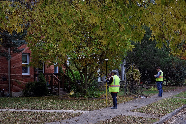
Staff from ASC Group conduct field survey in Dauphin County, 2019. Photo by Don Giles, PHMC.
Although often referred to as "architectural survey" or a "building survey," a survey project should look beyond buildings to include all the types of places that together form our historic landscape. Survey efforts often include bridges, canals, outbuildings, cemeteries, parks, gardens, landscape features, and other aspects of a built, or above ground, environment.
While professionals can be hired to conduct a survey, volunteer groups made up of individuals from non-professional preservation backgrounds can also contribute to survey in Pennsylvania. To learn more about how to get involved as a non-professional, please contact PAGS staff via Elizabeth Shultz at
elishultz@pa.gov or 717-346-9568.
Why conduct a survey?
Survey is fundamental to historic preservation because it acknowledges that older and historic places add value to our communities and help tell Pennsylvania's many stories. Conducting surveys and creating an inventory are important steps toward preserving resources important to our heritage.
There are a few reasons why surveys are conducted: planning, compliance, education and information.
For planning:
Surveys help Pennsylvania's communities, agencies and organizations identify the older and historic places that are historically and culturally significant and prioritize their preservation. Survey data informs decision making and community planning and is the basis for regulation of historic places at the local level.
The
Pennsylvania Municipalities Planning Code requires that communities develop comprehensive plans that include a historic preservation component to consider locally important historic resources. Fulfilling this requirement requires some form of identification of resources, most commonly a survey.
For more information on preservation planning, visit PHMC's
Community Preservation,
Certified Local Government and
Disaster Planning pages.
For compliance:
Federal or state agencies conduct compliance surveys as part of their responsibilities under Section 106 of the National Historic Preservation Act of 1966, as amended (NHPA) or the Pennsylvania History Code. These two pieces of legislation require federal and state agencies to take preservation values into consideration when they propose a project that may affect resources listed in or eligible for listing in the National Register.
Compliance surveys identify resources that may be affected by the agency's proposed project and evaluate if they are listed in or eligible for listing in the National Register. PA SHPO and other agencies use survey data as part of their environmental review and project design.
For more information about the PA SHPO's environmental review process, please visit PHMC's
Environmental Review pages.
For education and information:
Information gathered from a survey can provide insight into a community's past and tell a more complete story. Survey can increase public awareness and understanding about a community's older and historic places as assets.
Survey organized around a particular theme or time period serves as primary research for scholarly and academic study and contributes to a better understanding of the historical record. Many of the surveys conducted in Pennsylvania in the 1970s and 1980s resulted in thematic studies and historic contexts that are still used today.
For more information about thematic studies and historic contexts, please visit the PHMC's
historic contexts page.
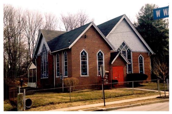
St. John’s African Methodist Episcopal Church in Radnor Township, Delaware County (Key #827777).
Photo taken for Radnor Township Survey, ca. 2003.
Levels of Survey
PA SHPO uses two different levels of survey, as outlined in the Secretary of the Interior's Standards and Guidelines:
Identification and
Evaluation.
Identification Level Survey
This level of survey is used for generally characterizing older and historic places and is often used to determine the basis for a more detailed survey. Identification level surveys are often referred to as "windshield" or "reconnaissance" surveys.
Identification level survey typically involves the following steps:
- Determining the survey methodology, including where, when, how, and why the survey will be conducted.
- Conducting a limited amount of background research, including a study of current and historic maps and aerial photographs to develop an understanding of the area's layout and development over time.
- Identifying previously surveyed resources, including those listed in or eligible for listing in the National Register of Historic Places.
- Completing fieldwork to document physical characteristics and take photographs. PA SHPO has established a minimum record for what information needs to be captured during field survey. At least one photograph of the main (primary) elevation is needed.
- Preparing an inventory and report to document the survey methodology and results.
The purpose of identification level survey is never solely to identify candidates for National Register eligibility. It is critical to remember that for planning purposes, resources that are important to a community should be considered for recordation regardless of National Register eligibility.
Evaluation Level Survey
An evaluation level survey involves a closer and more careful look at the older and historic places being surveyed than an identification level survey. This level of survey is designed to precisely and completely identify all historic resources within a given area or theme and provide enough information for PA SHPO to evaluate their eligibility for listing in the National Register of Historic Places. This level of survey is sometimes called "intensive" or "comprehensive" survey.
Evaluation level survey typically involves the following steps:
- Determining the survey methodology, including where, when, how, and why the survey will be conducted.
- Developing a summary history and historic context for the project area using primary and secondary sources, historic maps and photographs. The summary should include a clear and concise narrative history of the project area that highlights important trends in the area's development, important geographic, cultural, economic, and transportation influences, and significant events that impacted the project area's physical development.
- Identifying previously surveyed resources, including those listed in or eligible for listing in the National Register of Historic Places.
- Writing a survey plan that includes the results of steps 1, 2, and 3.
- Completing fieldwork to document physical characteristics and take photographs. PA SHPO has established a minimum record for what information needs to be captured during field survey. At least one photograph of the main (primary) elevation is needed.
- Preparing an inventory and final report to document the survey methodology, results, and recommendations for National Register eligibility.
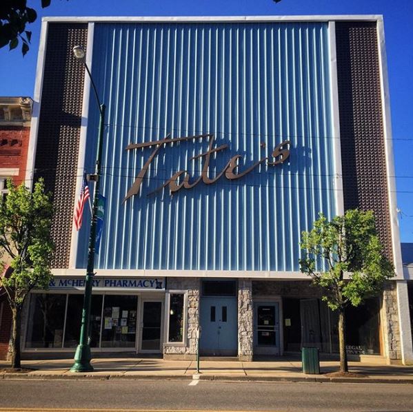
Department store in downtown Bradford, McKean County. PA SHPO staff photo, 2016.
FAQs
Q. How do I find out what has been surveyed in Pennsylvania?
A. Anyone can view the commonwealth's online inventory of older and historic places and archaeological sites through PA-SHARE, Pennsylvania's State Historical & Architectural Resource Exchange.
For more information about PA-SHARE, including detailed guidance for using PA-SHARE, visit the PA-SHARE page.
Q. I am completing a survey for an environmental review project. What are the data requirements for these surveys?
A. These types of surveys are typically conducted in consultation with PA SHPO's Environmental Review staff. The above ground project reviewer can assist with developing the survey scope and methodology. Contact information for above ground reviewers is available here.
PAGS staff can answer questions about required data fields, PA SHPO's minimum record, data formatting, digital submission, PA-SHARE, or related topics. Please contact Elizabeth Shultz at
elishultz@pa.gov or 717-346-9568.
Q. What is included in PA SHPO's minimum record for survey?
A. The minimum record includes:
- Location data (County, Municipality, Street Address)
- A map showing location
- Use data (Type, Ownership, Historic Use, Current Use)
- Description (Exterior Materials, Stories and Bays)
- At least one photograph.
Q. My community is interested in having volunteers do a survey. Where do we start?
A. If your group or organization would like to undertake a volunteer survey effort to document a collection of properties or a certain area, PAGS is equipped to provide information, guidance, and training on how to document resources and submit them to the PA SHPO, as well as provide assistance on other survey related questions and issues, such as developing survey plans and methodologies.
Please contact Elizabeth Shultz at elishultz@pa.gov or 717-346-9568 to get started.
Q. There is a historic building in my community that I think should be documented and added to PA-SHARE. What do I need to do?
A. To determine if an older or historic place is included in PA-SHARE, please refer to our instructions Searching for Resources and Other Information in PA-SHARE. To inquire about adding a place to PA-SHARE, please contact Elizabeth Shultz at elishultz@pa.gov or 717-346-9568.
Q. If PA SHPO adds survey data to PA-SHARE, does that mean that all of the places surveyed are now considered historic?
A. Submitting survey data to PA SHPO about a place does not automatically convey any historic status or place any restrictions on a property owner. If you are interested in having PA SHPO provide a determination of a property's eligibility for listing in the National Register of Historic Places, please contact Elizabeth Rairigh at
erairigh@pa.gov.
Additional Resources
For more information about the PAGS program, contact Elizabeth Shultz at
elishultz@pa.gov or 717-346-9568.
For more information about survey: