Apiary: An Apiary is a collection of equipment for the raising of honey bees for the collection of honey. The hives are housed in boxes situated near a good source of pollen. Apiarists move their hives frequently during the season as different plants come into blossom. Apiaries can be found in many parts of the state. | 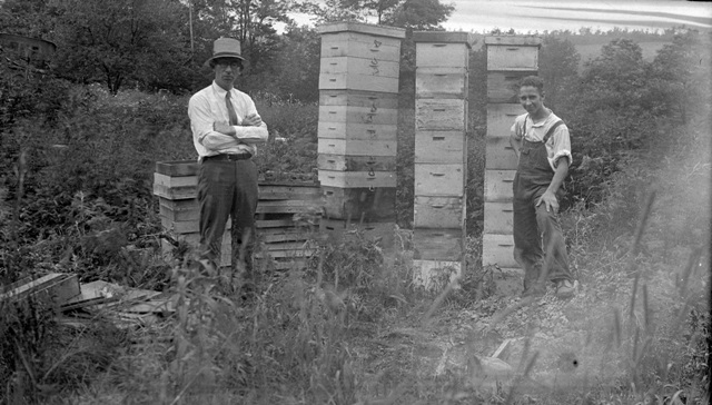 Apiary and bee keepers, 1931, Snyder County, PA State Archives, Record Group 1, SERIES #07-NEG#6205. Apiary and bee keepers, 1931, Snyder County, PA State Archives, Record Group 1, SERIES #07-NEG#6205.
|
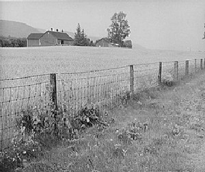
Boundary Demarcations: Farmers found a number of ways to mark the boundaries of their property, often utilizing hedgerows, arbor vitae or useful medium height plants such as wild blackberry or raspberry bushes. These could range from deliberately planted and maintained hedges or to boundaries planted naturally by birds and wildlife along an existing fence. Tree lines between fields or along property boundaries often survive since some trees live for many decades. Farmers also used various types of fencing. Historically, fencing was a big expense and building and maintaining fences accounted for a significant amount of time and labor. Early fence laws called for farmers to fence their crops, but later those laws shifted to require livestock owners to fence their animals. Typically, a farm would display a hierarchy of fencing with more elaborate finished fencing such as a picket fence or post and rail fence nearest to the house and the least refined fence farthest away. Early fencing material might also include stone, especially if it was locally available, to be placed in more prominent locations. The development of barbed wire in the late 19th century was quickly adapted to farm use. Woven wire fencing became popular in the early 20th century and was heavily used to safeguard livestock. |  Tree line, Franklin County Tree line, Franklin County
 Woven wire fence with a single strand of barbed wire, photo 1941, Centre County, Image from the Farm Security Administration, Office of War Information, Phot Collection LOC Prints & photographs Division, Digital ID fsa8b14632. Woven wire fence with a single strand of barbed wire, photo 1941, Centre County, Image from the Farm Security Administration, Office of War Information, Phot Collection LOC Prints & photographs Division, Digital ID fsa8b14632.
|
Contour Plowing: Contour Plowing follows the contours of hills and slopes of the terrain for the planting of crops. The technique was popularized during the New Deal and afterwards as a way to prevent soil erosion. Contour plowing furrows run crosswise to the slope of the land, slowing runoff and allowing the soil to absorb rainfall rather than wash away. Contour plowing usually employed along with strip cropping which alternates different crops in narrow strips of land. Dense-rooted crops planted between row crops further helped to make full use of rainfall. Contour Plowing and strip cropping demonstrate the evolving 20th century science of agriculture and the sharing of such knowledge through government agencies. | 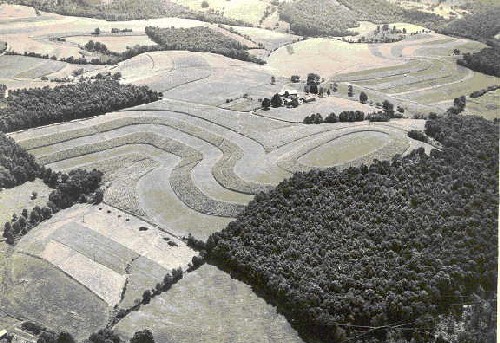 Aerial view showing contour plowing, strip cropping, windbreaks and woodlots, Burt DeWald Farm, circa 1950, Lycoming County, Photo from Lycoming County Agricultural Extension Archives. Aerial view showing contour plowing, strip cropping, windbreaks and woodlots, Burt DeWald Farm, circa 1950, Lycoming County, Photo from Lycoming County Agricultural Extension Archives.
|
Creeks and Streams: Creeks and Streams located on the farm were much prized during the settlement period and beyond. Flowing water provided many advantages and opportunities. | 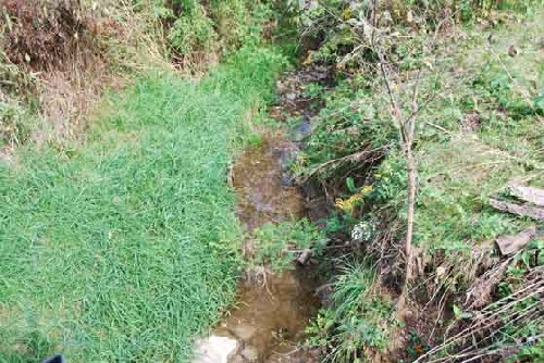 Farm stream. Farm stream.
|
Cropland: Historically, field crops were more varied than in contemporary Pennsylvanian agriculture and fields were generally smaller. Cropland today may show only the planting of corn, hay and soybeans. In the past corn, wheat, oats, barley, rye, hay, potatoes, cannery crops and buckwheat were commonly planted. | 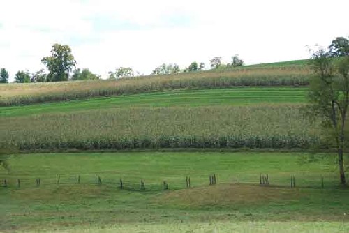 Crop field with little change since the early 20th century, 2008, Washington County. Crop field with little change since the early 20th century, 2008, Washington County.
|
Foundations: A ubiquitous archaeological feature found on farmsteads is the foundation. Foundations can be brick, dry-laid stone or mortared stone. Some buildings were not built on foundations, but were instead supported on stone or brick piers. | 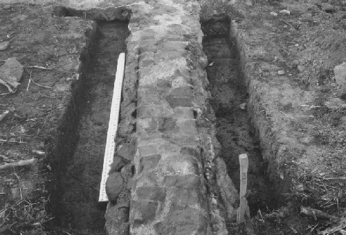 A mortared stone foundation was found just below the ground surface. A mortared stone foundation was found just below the ground surface.
|
Differential Vegetation: Some features leave no above-ground traces. Some, such as wells or privies can show up as depressions in the ground and some may be marked by differential vegetation. Even without excavation, one can tell that some sort of feature lies in a given area, although the date and function will likely not be evident. | 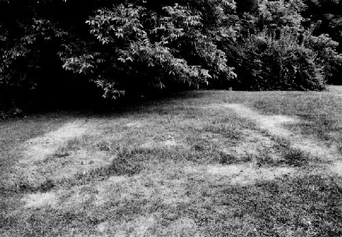 A foundation that is clearly marked by differential vegetation. A foundation that is clearly marked by differential vegetation.
|
Drainage: American farm drainage control began in 1830 with experiments in New York using tile pipes to channel water away from fields and into streams to make land more workable and productive. By the late 19th century there were thousands of miles of tile or stone lined or open ditch drains in the Mid-Atlantic and Midwest. Early ditches were hand dug, but as steam power and gasoline power trenchers were developed, digging trenches became more efficient and less burdensome. In the post –WWII era farm drainage efforts accelerated significantly due to government program subsidizing such efforts, more powerful equipment and vigorous promotion by the Soil Conservation Service and the Agricultural Extension Service. By the mid-20th century, questions about proper wetlands management were being raised since agriculture remained one of the largest agents in reducing wetland areas in the US. Between the mid-1950s and the mid-1970s, agricultural practices were responsible for the loss of 12 million acres of wetland. Wildlife advocates and conservationists objected to the US Dept. of Agriculture's subsidizing of drainage due to its environmental impact and urged legislation to protect wetlands. The 1970 passage of the National Environmental Policy Act (NEPA) and the Federal Water Pollution Control Act of 1972 and the 1977 Clean Water Act tightened regulation of federal support of farm drainage efforts. Recognizing farm drainage features beyond open ditches can be a challenge. Underdrains- tiled round pipes placed in trenches and then backfilled with soil – can be difficult to identify in the farm landscape. | 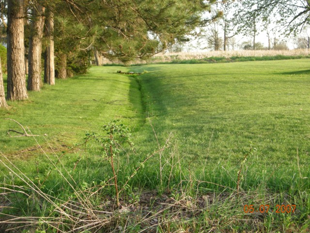 Open drainage ditch, Mercer County. Open drainage ditch, Mercer County.
|
Farm Cemetery: On some farms, private family cemeteries were carefully maintained for generations. | 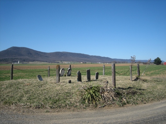 Farm Burial Ground, 19th century, Franklin County. Farm Burial Ground, 19th century, Franklin County.
|
Farm Lane: Farm Lanes provide interior pathways within a farm and occasionally connect one farm to another without using public roadways. Farm Lanes are important to the layout and efficiency of the farm in moving livestock, machinery and workers. | 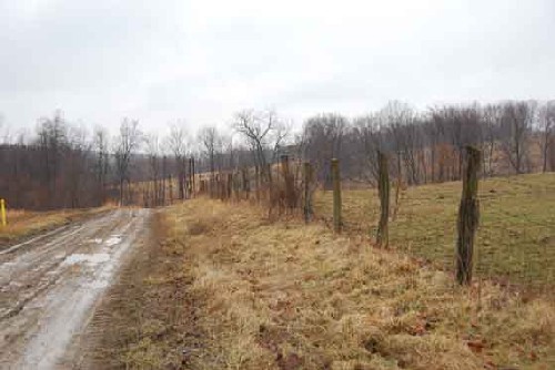 Farm Lane, image 2008, Greene County. Farm Lane, image 2008, Greene County.
|
Farm Pond: Farm ponds mainly date from the World War II period and thereafter. Pond building occurred as a response to a number of forces. Insurance companies encouraged them as fire suppressants and large-scale earth moving equipment was available for their construction. Interest in recreational uses arose with pond owners stocking them with fish and installing docks. Farm Ponds can be found throughout the state. | 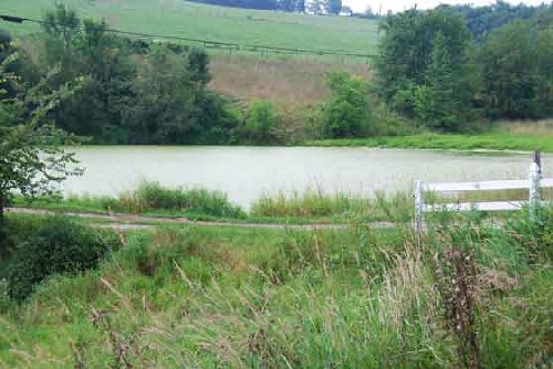 Farm pond, likely post 1945, Washington County. Farm pond, likely post 1945, Washington County.
|
Limekiln: A Limekiln is a hollow masonry structure used to burn limestone (calcium carbonate) to create lime (calcium oxide). Limekilns are round or square and built into a bank with the stones tapering from bottom to top. An opening at the bottom accommodated the flue. Inside the kiln, firewood was laid, topped with layers of coal and limestone. Once burning commenced, it took several days to reduce the stone to lime. Lime was used on farm fields as fertilizer and in the creation of masonry mortar and for plaster, whitewash and as a disinfectant. | 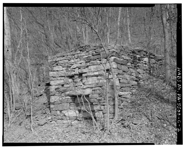 Limekiln, early 20th century, Clinton County, image from HABS, LOC Prints & Photograph Division, Digital ID hhh.pa3678. Limekiln, early 20th century, Clinton County, image from HABS, LOC Prints & Photograph Division, Digital ID hhh.pa3678.
|
Manure Lagoon: As nutrient runoff became a serious environmental problem, government regulations required more stringent handling of animal waste. Manure Lagoons appears in the late 20th century to address the issue. They serve as large holding tanks for animal waste and most date from sometime after the 1970s. |  Manure Lagoon, Chester County. Manure Lagoon, Chester County.
|
Mineshaft: In the anthracite and bituminous coal mining areas of Pennsylvania, some evidence of mining activity can be seen in agricultural landscapes. Mineshafts, small scale openings to access the coal under the ground can be found on farms. | 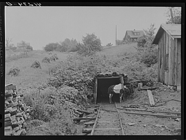 Mineshaft, photo date 1944 Clearfield County, Image from Farm Security Administration, Office of War Information Photograph Collection, LOC Prints & Photographs Division, Digital ID fsa8c03033. Mineshaft, photo date 1944 Clearfield County, Image from Farm Security Administration, Office of War Information Photograph Collection, LOC Prints & Photographs Division, Digital ID fsa8c03033.
|
Orchard: An Orchard is a plot of land devoted to the growing of fruit trees. At one time virtually every Pennsylvania farm had a substantial orchard, mainly apple trees. Typically, only remnants of these earlier orchards remain. However, in concentrated areas such as the Adams County fruit belt there are substantial acres of orchards.
| 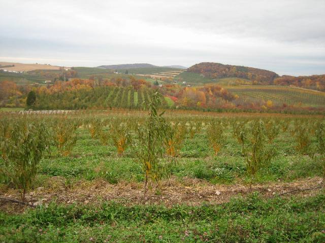 Orchard, image from 2008, Adams County. Orchard, image from 2008, Adams County.
|
Pasture: Pasture refers to land that is usually kept in permanent grasses and other plants for the grazing of livestock. As of data collected in 2002 most Pennsylvania counties had relatively little pasture land, while nationally, close to half of the US farmland was in pasture. In Pennsylvania less than 30% of the farmland is in pasture. While historical comparisons are difficult, it is likely that Pasture lands have decreased in proportion to the total Pennsylvania farm acreage. One explanation is the preference for feeding animals grain and silage and relying less on pasture. Another possibility is the drop-in dairy activity overall in Pennsylvania. There has been an increased interest I organic livestock raising and rotational grazing in the early 21st century. | 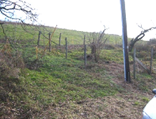 Pasture surrounded with woven wire fencing. Pasture surrounded with woven wire fencing.
|
Springs: The location of Springs was an important determinant in farm selection and building siting. During the settlement period and long after, prospective farm families needed a water source for themselves and their livestock. A Spring is a site where ground water flows to the surface either from seepage or from underground aquifers. Spring sites were much prized and carefully protected either with simple roofs or by the erection of more elaborate spring houses. | 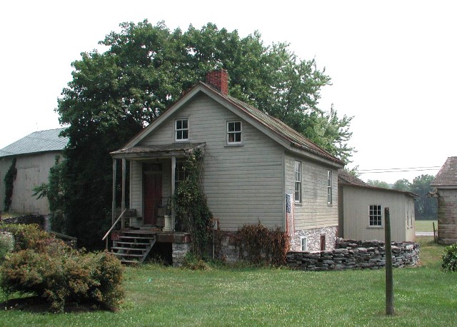 Small Spring House and stone wall enclosing a spring, near the Summer Kitchen, circa 1850, Lebanon County. Small Spring House and stone wall enclosing a spring, near the Summer Kitchen, circa 1850, Lebanon County.
|
Water Tank: On some farms water could be pumped from the groundwater supply to be held in a tank. In Adams County water tanks are situated in the orchards so that water spraying machines can be filled on site. | 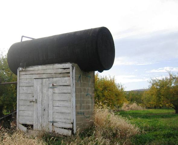 Elevated water tank set on a pump building, circa 1970, Adams County. Elevated water tank set on a pump building, circa 1970, Adams County.
|
Well Head: Well heads are above ground pumps for extracting water or oil or gas from underground. In many parts of the state extractive industries have long coexisted with agriculture. Natural gas piping and wellheads are especially common in the western, southwestern and northwestern portions of the state. Though the oil and gas industries are well over a half century old, few of the fixtures found in Pennsylvania are older than 50 years. | 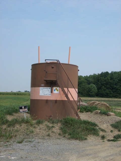 Oil or Natural Gas Tank, late 20th century, Mercer County. Oil or Natural Gas Tank, late 20th century, Mercer County.
|
Windbreak: A Windbreak is a row of closely placed trees or shrubs near a farmhouse to provide protection from winds. Most often Windbreaks are formed from evergreen trees. They were popularized during the New Deal era of the 1930s and are now common throughout the state. | 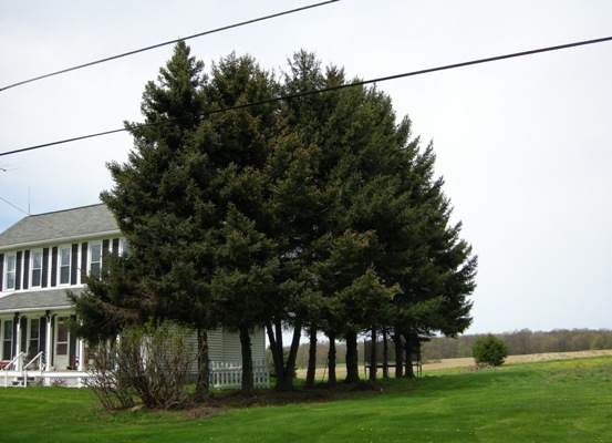 Evergreen Windbreak, Lawrence County. Evergreen Windbreak, Lawrence County.
|
Windmill: A Farm Windmill is a device equipped with blades and often a rudder designed to move with wind power and transfer the energy to power small machines such as pumps. | 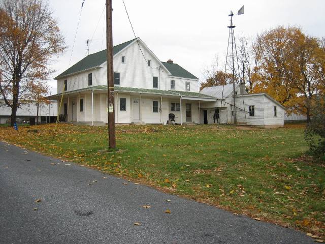 Windmill located next to a farmhouse, circa 1925- 1940, Adams County. Windmill located next to a farmhouse, circa 1925- 1940, Adams County.
|
Woodlot: Woodlots located close to farms were useful in a variety of ways. Trees were used for lumber for fences and for chopped wood for heating and cooking. Lumber could also be harvested for sale to be cut into railroad ties and other commercial purposes. If the woodlots contained the right type of trees, they could also be used in the production of maple sugar. | Aerial view of Burt DeWald Farm showing woodlots, photo circa 1950, Lycoming County, Image from Lycoming County Agricultural Extension Archives.
|